Climbing Mount Meru in Tanzania
Mount Meru is a dormant stratovolcano located 70 kilometres (43 mi) west of Mount Kilimanjaro in the nation of Tanzania. At a height of 4,562.13 metres (14,968 ft), it is visible from Mt Kilimanjaro on a clear day, and is the fifth-highest mountain in Africa, depending on the definition.
Mount Meru is located just north of the city of Arusha, in the Arusha Region of Tanzania. It is the second-highest mountain in Tanzania, after Mount Kilimanjaro. The Momella route – which starts at Momella gate, on the eastern side of the mountain – is used to climb Mount Meru.
Climbing Mt. Meru is usually skipped in favour of its larger neighbour Mt. Kilimanjaro to the west, but the sheer beauty and challenge of this three-day climb makes it a must-to-do activity for obliging itineraries.
The early parts of the trail pass through lush rainforests of fig trees and colubus monkeys high in the canopy.
As you climb higher, the cloudy forest clears in the late afternoon to reveal striking vistas of Kilimanjaro and the volcano chain on the edge of the Rift Valley.
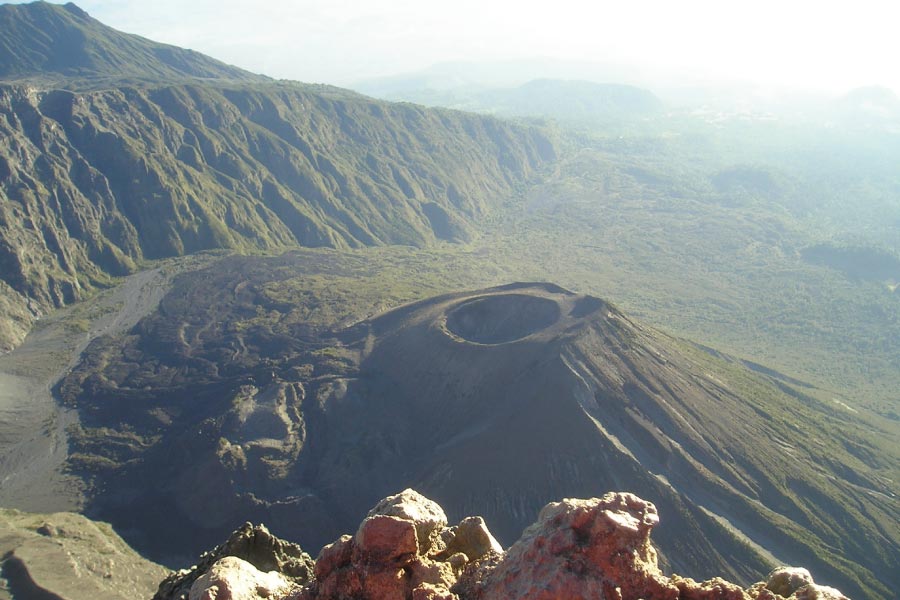
The last distance before the summit passes over the crater ridge.
It is an exhilarating experience, and it is not one for the faint-hearted. So while Kilimanjaro offers the chance to scale to the ‘roof of Africa’; its slightly smaller neighbour is certainly not lacking the adventure.
Why you should go.
Although this is a spectacular mountain with amazing scenery and wildlife, it’s location in East Africa means that most international visitors will visit Mount Meru as a secondary trip in conjunction with their primary destination, usually Kilimanjaro, Mount Kenya, or the Ngorongoro Crater.

Reasons to do this summit include:
- Amazing views into the summit crater and ash cone,
- Hiking along the crest of the crater rim,
- Nice, but distant, views of Kilimanjaro from the summit,
- The ability to see a lot of wildlife on the lower slopes in the form of a walking safari,
- The chance to escape the tourist crowds, and
- For Americans, the ability to summit another peak taller than Mount Whitney.
Arusha National Park provides certificates for people who summit the Little Meru sub-peak (3,820 m / 12,533 ft) or Socialist Peak – aka the Mount Meru summit. Although the name Socialist Peak is listed on the summit certificate, this name was rarely used and given that the Tanzanian government is moving more towards capitalism, it will probably never be more than a curiosity.
The 14 km (8.7 mi) or 19 km (11.8 mi) YDS class 2 Momella Route is the primary and only official route to the summit today. This route starts at the Momella Gate (1,500 m / 4,921 ft) and uses one of two tracks to Miriakamba Hut (2,514 m / 8,250 ft), either a shorter 5 km YDS class 1 route or a longer 10 km YDS class 1 route that allows one to see more wildlife, scenery including waterfalls, and old huts. From the Miriakamba Hut, you take a 4 km YDS class 1 trail through some forests up to the Saddle Hut (3,566 m / 11,700 ft). From Saddle Hut, you can either summit Little Meru (3,820 m / 12,533 ft) or follow the route another 5 km YDS class 2 to the Mount Meru Summit, aka Socialist Peak. On the way up to the summit from Saddle Hut, the first notable bald area you’ll reach is Rhino Point where you can get amazing views of the summit and the inner crater walls, providing there are no clouds. You’ll know you are at Rhino Point because there is a pile of bones in the center of the clearing. The easy YDS class 2 portion of the hike involves crossing two moderately long low-angle rock slabs above Rhino Point. Also from Rhino Point to the summit, there are green blazes and arrows painted on the rocks to show you the way, however, these can be hard to see at night. There is a metal flag of the United Republic of Tanzania on the summit as well as a wood box and summit register.
Before Mount Meru was included in Arusha National Park in 1967 it was also possible to reach the summit via the North and West Slopes, however, use of these trails to enter the park (and reach the summit) is now illegal. It is, however, legal to climb the inner Ash Cone but the park only recommends this for researchers and issues a special permit for this activity.
Getting there
MOMELLA GATE: Most people who visit Arusha National Park make a visit to and stay at either Arusha (1,387 m / 4,550 ft) or Moshi (831 m / 2,726 ft), the closest towns to Mount Meru. The major international airports used to access these northern Tanzania towns include (order from most convenient to least): Kilimanjaro International Airport (code: JRO), Nairobi, Kenya (code: NBO), or Dar es Salaam (code: DAR).
From either of the towns take the A23 (aka Arusha-Moshi Road) to Usa River Village about 10 km east of Arusha and just west of the Lake Jipe Bar. From here turn north on to the dirt access road and follow it about 30 km until you reach Momella Gate. The access road is fairly rocky so if you hire a car, a 4WD is recommended. There are no regular buses or public transportation to the park so you will have to walk, hire a car, hire a taxi, or hitch a ride. Often times you will be able to hitch a ride from the A23 junction as well as Momella Gate.
When to go
Generally, the best times to climb Mount Meru peak are from June to February with occasional rains in November. The dry season is from July to March. December to February generally offer the best views of Kilimanjaro which can often be seen from the summit and most places in Arusha National Park.